Planning a trip to the Fagradalsfjall volcano in 2026 offers a unique encounter with Earth’s raw power. Standing beside a landscape freshly sculpted by volcanic activity is an experience unlike any other. This guide provides essential, safety-first 2026 information for a memorable volcanic adventure. It covers real-time safety updates, trail details, and the best Iceland volcano tours available. This resource will help you plan an adventure focused on understanding and experiencing a dynamic, living landscape. For a broader look at Icelandic volcanic experiences, check the main site.
Understanding Fagradalsfjall: A Brief History & Geological Context
Fagradalsfjall, part of the Reykjanes volcanic system, is a shield volcano – relatively flat and broad – with a recent history of dramatic eruptions. Before 2021, the Reykjanes Peninsula had been dormant for nearly 800 years. In March 2021, lava broke through the surface in the Geldingadalur valley, beginning a series of effusive eruptions that gained global attention.
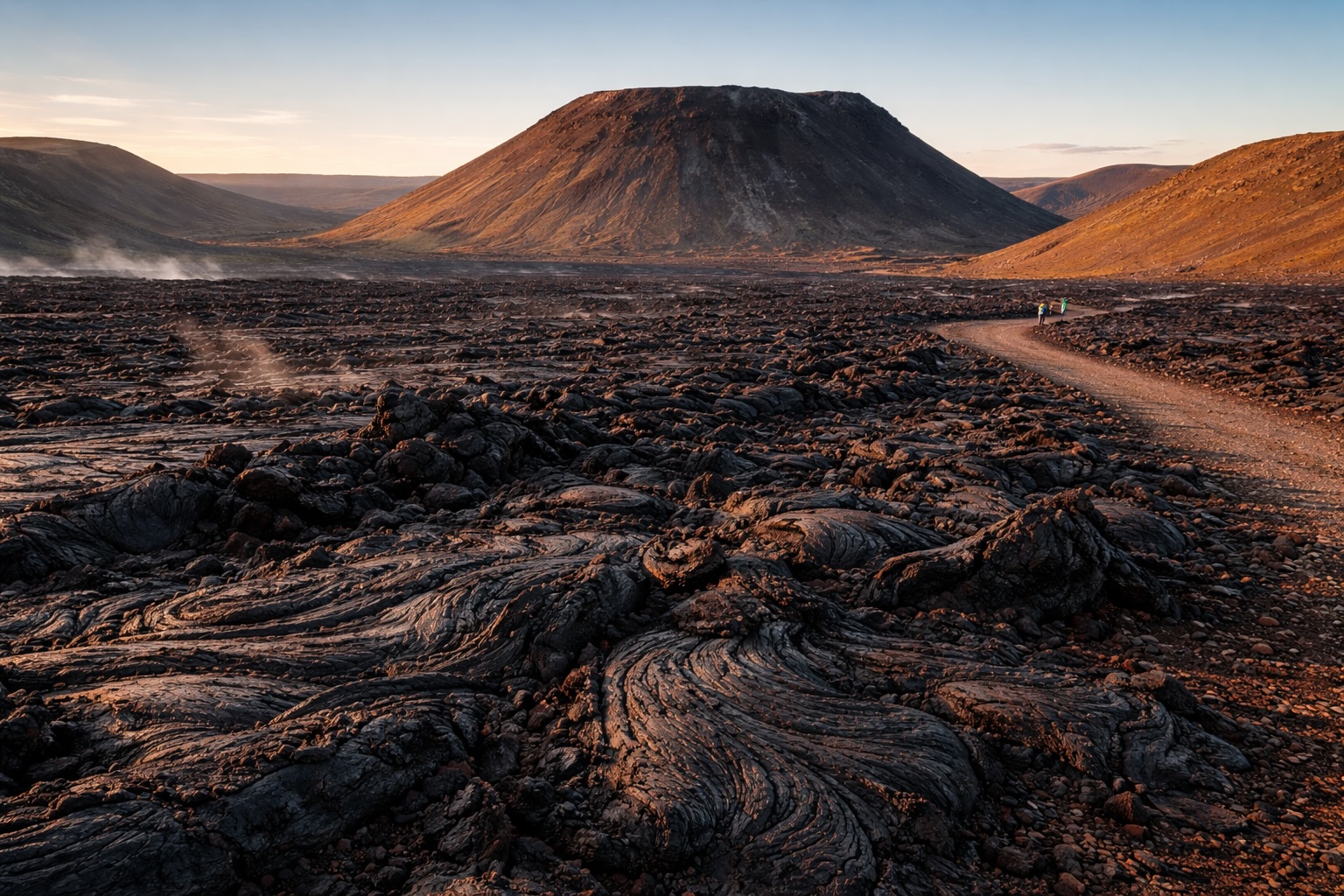
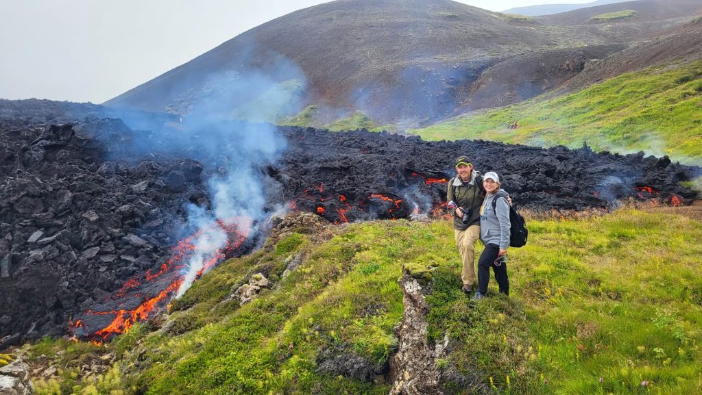
This initial eruption lasted for months, creating vast new lava fields that reshaped the valley floor. A significant eruption followed in Meradalir in August 2022, and a third near Litli-Hrútur in July 2023. Each event added new layers of rock, cooled and hardened, but still radiating the heat and steam of their recent formation. Hikers traverse these fields, a reminder of the planet’s continuous creation. It offers a direct view of geological processes normally hidden deep underground.
Fagradalsfjall Volcano: Current Status & Safety for Your 2026 Hike
Is it safe to hike Fagradalsfjall in 2026? The answer, like most things with active volcanoes, is dynamic. While the immediate area of Fagradalsfjall itself has seen no new eruptions since 2023, the wider Reykjanes Peninsula remains geologically active. Always check official, real-time sources right up to the moment you step onto the trail.
Your primary authorities are:
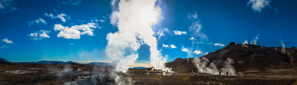
- The Icelandic Met Office (Veðurstofa Íslands): This provides the most up-to-date information on seismic activity, volcanic tremors, and gas pollution forecasts. Volcanic gases, particularly sulfur dioxide, can be dangerous, especially in certain wind conditions or low-lying areas.
- SafeTravel.is: Operated by the Icelandic Association for Search and Rescue (ICE-SAR), SafeTravel provides real-time alerts, road closures, and specific trail status updates. If SafeTravel advises against hiking, or if trails are officially closed, do not go. No exceptions. They are the ultimate arbiter of safety on the ground.
While geographically distinct, the ongoing seismic and volcanic activity closer to Grindavík, while concerning for that town, may indirectly impact the Fagradalsfjall hiking area’s accessibility or safety. Authorities are exceptionally vigilant, and if the regional situation changes significantly, access to Fagradalsfjall could be temporarily restricted as a precaution. Daily checks on SafeTravel.is are essential.
Safety Precautions for Volcanic Areas
- Stay on Marked Trails: This is paramount. The ground, especially newly cooled lava, can be unstable. Hidden fissures, fragile crusts over still-hot lava tubes, or sudden drop-offs can exist. This is a rule for your own survival.
- Gas Pockets: Hot spots and fissures emit odorless, deadly gases like carbon dioxide, especially in depressions or calm weather. If you feel dizzy, lightheaded, or unwell, move to higher ground immediately.
- Heat: Even cold-looking lava fields retain significant heat just beneath the surface. Do not touch them directly and avoid sitting on them.
- Footing: The terrain is uneven, sharp, and shifting. Loose scree, jagged rocks, and slippery mud are all possible. Sturdy, ankle-supporting footwear is critical.
- Weather: Icelandic weather changes fast. Fog can roll in, visibility can drop to zero, and winds can reach gale force in minutes. Being prepared for everything is not optional.
How to Get to Fagradalsfjall: Transport Options & Parking Information
Getting to the Fagradalsfjall trailhead from Reykjavik is straightforward, but requires planning. The volcano is on the Reykjanes Peninsula, roughly 40 – 50 kilometers (25 – 30 miles) southwest of Reykjavik, and about 20 – 30 kilometers (12 – 18 miles) from Keflavik International Airport (KEF).
Driving from Reykjavik:
This is the easiest and most flexible option for most independent hikers. Take Route 41 (Reykjanesbraut) southwest from Reykjavik. Near Grindavík, turn onto Route 427 (Suðurstrandarvegur). Look for signs indicating “Geldingadalir” or “Volcano Parking” – these are clear. The drive from Reykjavik takes about 45 – 60 minutes, depending on traffic and road conditions.
Parking:
- Designated Lots: Several designated parking areas (P1, P2, P3) are along Route 427. P1 is often the closest to the main hiking routes, though this changes based on open paths. These are managed by Parka.is, a digital parking system.
- Payment: Download the Parka app on your smartphone before you go, or pay online via parka.is. It costs around 1,000 – 1,200 ISK for the day in 2026. No cash payment options exist, so plan ahead. You get a few minutes grace period to scan a QR code and pay. Failure to pay results in a fine.
- Availability: Parking fills up, especially on weekends, during good weather, or peak summer. Arriving early (before 9:00 AM) or later in the afternoon (after 3:00 PM) helps avoid the worst crowds.
From Keflavik Airport (KEF):
The drive from KEF is shorter, typically 20 – 30 minutes. Head south on Route 41, then connect to Route 427 as above.
Public Transport:
No direct public bus service from Reykjavik or KEF goes specifically to the Fagradalsfjall trailhead. While you can take a Strætó bus to nearby towns like Grindavík, you would then need to arrange a taxi or another ride for the final several kilometers to the parking area, which is neither convenient nor cost-effective. For this reason, renting a car or joining a guided tour are the most practical solutions.
Choosing Your Adventure: Fagradalsfjall Hiking Trails & Routes Explained
The landscape around Fagradalsfjall is a dynamic canvas, constantly changing with new lava flows. For 2026, the primary hiking areas focus on the cooled lava fields from the 2021, 2022, and 2023 eruptions. Older paths may be inaccessible or re-routed, so always defer to current signage.
The main accessible route in 2026 leads to the Geldingadalur valley and offers views of the 2021 lava fields and craters. A path often leads further towards the 2022 and 2023 eruption sites (Meradalir and Litli-Hrútur, respectively), but these are longer and more strenuous.
Here’s what to expect, usually starting from Parking P1 or P2:
Main Route: Geldingadalur & Lava Fields (Often referred to as Path A or similar)
- Difficulty: Moderate.
- Length: Approximately 6 – 8 km (3.7 – 5 miles) round trip.
- Estimated Time: 2.5 – 4 hours (active hiking time). Allow extra for photos, breaks, and observation.
- Elevation Gain: Around 200 – 300 meters (650 – 1000 feet) depending on the exact viewpoint. This path includes steady uphill sections.
- What you see: This path generally crosses older, moss-covered lava fields and then onto the newer, black, rougher fields from 2021. You will view the original Geldingadalur crater and the vast expanses of cooled lava, which still steam in places. The scale of new land is striking. You might also see small plumes of gas escaping from the ground.
- Trail Conditions: The trail starts relatively easy but quickly turns into uneven, rocky, and sometimes muddy terrain. Sections can be steep and require careful footing. Always pay attention to trail markers (typically poles with reflective tops).
Extended Route: Towards Meradalir & Litli-Hrútur (2022 & 2023 Lava Fields)
- Difficulty: Challenging.
- Length: 14 – 20 km (8.7 – 12.4 miles) round trip, depending on how far you go.
- Estimated Time: 5 – 8 hours (active hiking time). This requires a full day.
- Elevation Gain: Up to 400 – 500 meters (1300 – 1600 feet).
- What you see: These longer routes go deeper into the newer lava fields, offering different perspectives of the recent eruptions. The terrain is more rugged and less developed than the main Geldingadalur path. Views may include craters formed in 2022 and 2023, and more active steaming from the cooling rock. This provides a clear sense of the landscape’s continuous transformation.
- Trail Conditions: These paths are significantly more challenging, with steeper climbs, looser scree, and longer stretches across highly uneven, sharp lava. They are exposed to strong winds and rapidly changing weather. Visibility can also be an issue.
These trails are not casual walks. They demand respect for the environment and a realistic assessment of your own fitness and preparedness. Always stick to the marked routes for safety.
Guided Tour vs. Self-Guided Fagradalsfjall Hike: Making the Right Choice
Deciding whether to go with a guided tour or hike Fagradalsfjall on your own is a key decision. Both options have benefits and drawbacks, depending on your experience, budget, and desired flexibility.
| Criteria | Self-Guided Hike | Guided Hike |
|---|---|---|
| Price | Low (parking ~€8, fuel). Requires car rental, which is a significant cost. | Moderate to High (from €70 – €200+, depending on tour type). |
| Safety | Your responsibility; requires constant vigilance & research of conditions. | High; expert local guides know terrain, weather, and emergency protocols. |
| Route Flexibility | High; go at your own pace, choose your own viewpoint. | Limited to tour itinerary; pace set by the group, less personal autonomy. |
| Transport | Requires own/rental car; includes driving & parking stress. Parking can fill up. | Included (often hotel pickup); no driving/parking hassle. |
| Local Insights | Minimal, unless you’ve done extensive research. | Good; guides provide geological context, stories, safety advice. |
| Gear Provided | None; bring all your own. | Often includes safety gear (headlamps, sometimes poles, rain gear). |
| Best For | Experienced hikers, those with a rental car, tight budget, desire for full autonomy, and diligent safety checkers. | First-time volcanic hikers, solo travelers, those without a car, groups wanting an expert-led experience, and those prioritizing safety and information. |
Verdict: If you have a rental car, are an experienced hiker, and are diligent about checking official safety and weather updates, a self-guided hike offers maximum flexibility. For most first-time visitors, especially those without a car or experience in volcanic terrain, a guided tour offers valuable safety, peace of mind, and a more informative experience. Guides often enhance the understanding of this landscape.
Top Fagradalsfjall Volcano Tours for 2026
If you prefer a guided experience, here are some of the best tour options available in 2026. These tours are designed to make your volcanic adventure safe, informative, and impactful.
Iceland hiking tour to Fagradalsfjall volcano with local guide
💰 From $169 per person | 👥 Small group & private options | ⏱ All Day | 📍 Pickup from Reykjavik
A local-guided hike to Fagradalsfjall, led by guides who witnessed the eruptions first-hand. Walk across dramatic lava fields, view steaming craters, and explore the eruption zone. The tour also includes the evacuated town of Grindavík, geothermal area of Seltún, and lake Kleifarvatn — stops most tours skip.
Highlights: Certified local guides · Real eruption experience · Grindavík · Seltún · Kleifarvatn · No rush pace
Fagradalsfjall Sunset & Photography Hike
❗️Top rated | 💰 From $160 per person | 👥 Max 6 people | ⏱ 7 – 9 hours | 📍 Pickup from Reykjavik
Guided hike to Fagradalsfjall with a certified geologist/volcanologist. Drive through older lava fields, explore recent eruption sites, walk to the crater viewpoint, and learn how the lava is still forming new land. Return via a scenic drive past hot springs, lakes, and mountains of the Reykjanes Peninsula.
⚠ Not suitable for: children under 12, pregnant women, people with mobility or respiratory issues. Active lava view not guaranteed. Tour may cancel due to weather, gas levels, or road closures.
Small Group with Local Guide — Fagradalsfjall Volcano Hike
💰 From $147 | 👥 8 people | ⏱ 4 – 6 hours | 📍 Pickup from Reykjavík or self-drive
This offers flexibility and personalized attention. A private guide tailors the day to your group’s fitness level and interests, combining the volcano hike with other highlights of the Reykjanes Peninsula, such as dramatic coastlines, geothermal areas, or the Bridge Between Continents. You set the pace, and the guide provides undivided attention and local knowledge. This is a higher investment but offers a tailored adventure.
⚠ Red lava not guaranteed — eruptions are unpredictable. Seltún/Kleifarvatn stops may be closed in winter. Not suitable for: children under 2, pregnant women, people with mobility or respiratory issues.
Helicopter Tour over Fagradalsfjall Volcano & Reykjanes Highlights
💰 From $565 per person | 👥 6 people | ⏱ 40 – 60 minutes (flight time) | 📍 Reykjavik domestic airport
A 30–40 min scenic helicopter flight over the Reykjanes Peninsula — 12 eruptions in the last 4 years, just 30 km from Reykjavík. Fly over fresh lava fields, smoldering craters, and streams of cooled lava. Aerial views of Fagradalsfjall, Litli Hrutur, Geldingadalir, Grindavík, Mount Esja, and Faxaflói Bay.
⚠ Visible lava not guaranteed — eruptions are unpredictable. Flights are weather-dependent. Min. 4 passengers required. Passengers over 120 kg must book an extra seat.
What to Wear & Pack: Essential Gear for Your Fagradalsfjall Hike
Icelandic weather is famously fickle, especially on exposed volcanic terrain. Being prepared is about safety. Do not underestimate the conditions.
Here’s what to wear and pack:
Clothing Layers (The “Icelandic Way”):
- Base Layer: Moisture-wicking thermal underwear (top and bottom), even in summer. Synthetics or merino wool are best. Avoid cotton, which stays wet and chills you.
- Mid-Layer: A fleece jacket or thick wool sweater. This provides insulation.
- Outer Layer (Shell): Essential. A windproof and waterproof jacket and trousers are necessary. Look for Gore-Tex or similar breathable, waterproof materials. The wind on the peninsula can be relentless, even without rain.
- Warm Hat & Gloves: Even on a mild day, cold wind can cut through. Protect your extremities.
- Warm Socks: Wool or synthetic hiking socks (bring an extra pair).
Footwear:
- Sturdy Hiking Boots: Waterproof, ankle-supporting hiking boots are paramount. The terrain is rocky, uneven, and can be very muddy or icy. Trainers or fashion boots are not suitable.
Essential Gear:
- Water (1.5 – 2 liters per person): No potable water is available on the trail.
- Snacks: High-energy snacks like nuts, energy bars, fruit.
- Headlamp/Flashlight: Bring one even if you plan a daytime hike. Weather can worsen, or your hike could take longer than expected, leading to low light or darkness.
- Small Backpack: To carry your layers, water, and snacks.
- First-Aid Kit: Blister plasters, pain relievers, antiseptic wipes, any personal medications.
- Navigation: A fully charged phone with offline maps (e.g., Google Maps, Maps.me) and a portable power bank. While trails are marked, visibility can drop suddenly.
- Sun Protection: Sunglasses (even on cloudy days, UV is strong), sunscreen.
- Camera: To capture the landscapes. Consider protection from dust and moisture.
Layers are key. You might shed layers during a climb and then bundle up seconds later as the wind picks up or you stop for a break.
Best Time to Hike Fagradalsfjall: Seasons, Weather & Crowds
Timing your Fagradalsfjall hike balances daylight, weather predictability, and crowd levels.
Summer (June – August)
Fagradalsfjall can be visited year-round, but the experience varies dramatically depending on when you go. Summer offers the most forgiving conditions for most hikers, while other seasons reward those willing to deal with harsher weather with far fewer crowds. Here’s what to expect from each season — starting with the most popular window.
- Daylight: Almost 24 hours of daylight in June and July. This provides ample time to hike and allows late starts to avoid crowds.
- Weather: Generally the mildest, with average temperatures around 10-15°C (50-59°F). However, rain and strong winds are common.
- Crowds: This is peak tourist season. Expect more people on the trails and parking lots to fill up faster.
- Visibility: Often good, but summer can bring unexpected fog.
- Best for: Most people. Offers a good weather window and long daylight. Go early morning (before 9 AM) or late evening (after 6 PM) for fewer crowds.
Shoulder Seasons (April – May & September – October):
- Daylight: Good daylight hours, gradually increasing in spring and decreasing in autumn.
- Weather: More unpredictable. Spring can be wet and windy; autumn offers crisp days but with a higher chance of cold snaps and early snow. Average temperatures 0-10°C (32-50°F).
- Crowds: Significantly fewer people than in summer, offering a calmer experience.
- Visibility: Varies day-to-day. Autumn colors can be appealing.
- Best for: Those seeking fewer crowds and willing to brave more varied weather. Good for photographers.
Winter (November – March)
Best Time of Day:
- Early Morning (before 9:00 AM): Fewer crowds, often calmer winds, softer light for photography.
- Late Afternoon (after 3:00 PM): Crowds thin out, good golden light, but be mindful of daylight hours, especially outside of summer. A sunset hike can be appealing if timed right, but requires headlamps for the return.
What to Expect on the Trail: Realistic Tips & Visitor Facilities
Here are some realistic expectations for your Fagradalsfjall adventure. This is a proper hike in a rugged, dynamic environment, not a casual park stroll.
- No Guaranteed Lava: This is a crucial expectation. By 2026, the eruptions at Fagradalsfjall itself have ceased. You will be hiking across cooled lava fields and seeing craters. You will not see glowing, flowing lava unless a new eruption spontaneously starts (which is unpredictable and would likely lead to trail closures). You will see steaming cracks and vents, and the ground will often feel warm. The beauty lies in the scale of the new land and the geological story it tells.
- Unpredictable Conditions: One minute it is sunny, the next you may encounter a sideways hail storm. Visibility can drop to nothing with fog. The wind is a constant presence. These are real possibilities.
- Difficult Footing: The trails are not paved. They are composed of jagged, uneven lava rock, loose scree, and mud. It is hard on the ankles and knees.
- Minimal Facilities:
- Toilets: Portable toilets (Porta-Potties) are typically available at the main parking areas (P1/P2). Do not expect luxurious facilities. No restrooms are available along the actual hiking trails. Plan accordingly.
- Emergency Services: ICE-SAR (Icelandic Search and Rescue) maintains a presence, especially during peak times or active periods. A small shelter or information point may be at the trailhead.
- Food Vendors: Sometimes, especially in peak season or good weather, a food truck or coffee cart operates near the main parking lot. Do not rely on this for your main meal or supplies; bring your own.
- Drone Restrictions: While drones capture footage, rules are in place. Always check local signage. Drones are typically restricted or prohibited near emergency response personnel, in areas with high visitor traffic, or if an eruption is active. Respect privacy and do not fly over people.
- Collecting Samples: Do not collect lava rocks or other geological samples. Removing anything from the natural environment is prohibited. Leave no trace.
- What to do if Weather Worsens:
- Assess immediately: Is it just rain, or is visibility dropping, or winds picking up dangerously?
- Turn back: If conditions rapidly deteriorate to a point where you feel unsafe or disoriented, turn back to the trailhead. It is better to cut a hike short than to get lost or injured.
- Use your phone/GPS: If lost, use your phone’s GPS to find your way back to the marked trail or a known landmark.
- Contact emergency services: In a true emergency (injury, severe disorientation), call 112. Have the SafeTravel app installed; it allows you to send your location to rescuers.
Budgeting Your Trip: Fagradalsfjall Hike Cost Breakdown
Understanding potential costs helps you plan effectively. Here is a realistic look at expenses for a Fagradalsfjall volcano hike in 2026.
Self-Guided Hike
- Rental Car: This will be your largest cost. Expect €50 – €150+ per day for a basic 2WD car, plus fuel. A 4×4 is not necessary for the main roads to Fagradalsfjall.
- Fuel: Iceland has high fuel prices. A round trip from Reykjavik will consume some, especially if you explore other Reykjanes sights.
- Parking Fee: Approximately 1,000 – 1,200 ISK (roughly €7 – €9) per day, via the Parka app.
- Food/Water: Bring your own, so this is part of your general grocery budget.
- Gear: If you need to buy specific hiking gear (boots, waterproofs), this is a one-time investment.
Guided Tour
- Tour Price:
- Group Hike: Expect €70 – €150 per person for a half to full-day tour. This includes transport from Reykjavik, a guide, and sometimes basic safety gear.
- Sunset/Photography Tour: Slightly higher, €100 – €200 per person, due to specialized focus and longer hours.
- Private Tour: Significantly more, starting from €600+ for a small group (1-4 people) for a full day, offering tailored experiences.
- Helicopter Tour: This is a premium experience, typically €350 – €500+ per person for a 45-60 minute flight.
- Tips: While not mandatory, tipping your guide for excellent service is appreciated.
- Food/Water: Some tours include snacks or a light meal; check what’s included. Otherwise, bring your own.
Overall Cost Considerations:
- Total for Self-Guided (Day Trip): €60 – €160+ (car rental, fuel, parking) + your own snacks. This does not include the higher upfront cost and commitment of a rental car.
- Total for Guided (Day Trip): €70 – €200+ per person. While higher upfront, this removes car rental, fuel, and parking stress, and adds expert guidance.
Booking tours in advance, especially during peak season, helps secure your spot and sometimes offers better rates.
Fagradalsfjall Volcano Hike FAQ
Is the Fagradalsfjall volcano currently safe to hike in 2026, and how can I check for updates?
Yes, the Fagradalsfjall eruption sites have been calm since 2023, making them generally safe for hiking in 2026, provided conditions allow. However, the wider Reykjanes Peninsula is still active, so it is critical to check real-time updates from SafeTravel.is (for trail closures and safety alerts) and the Icelandic Met Office (Veðurstofa Íslands) for seismic activity, weather, and gas pollution forecasts. These sites are updated constantly and are your most reliable source, offering detailed, localized information beyond general safety.
How difficult is the Fagradalsfjall hike for someone with average fitness, and what’s the elevation gain?
For someone with average fitness, the main hike to the 2021 lava fields (Path A) is considered moderate. It involves a round trip of 6-8 km (3.7-5 miles) and an elevation gain of roughly 200-300 meters (650-1000 feet). The challenge comes more from the uneven, rocky, and sometimes muddy terrain than from extreme steepness. Longer routes to the 2022/2023 sites are significantly more challenging, up to 20 km (12.4 miles) with 400-500 meters (1300-1600 feet) of gain, requiring greater endurance and longer time allocation.
What’s the best way to get to Fagradalsfjall from Keflavik Airport (KEF)?
The best way is by rental car. The drive from KEF takes about 20-30 minutes. You will take Route 41 south, then connect to Route 427 (Suðurstrandarvegur) and follow signs for volcano parking (P1, P2). There is no direct public transport from the airport to the trailhead; relying on public transport would necessitate multiple connections and a costly taxi for the final leg.
Can I hike Fagradalsfjall solo, or is a guided tour strongly recommended for first-timers?
You can hike Fagradalsfjall solo, especially if you have a rental car, are an experienced hiker, and are diligent about checking all safety and weather forecasts from official Icelandic sources right up to your departure. However, for most first-timers, a guided tour is strongly recommended. Guides provide crucial safety oversight, interpret the landscape’s geology, and handle all transportation logistics, removing much of the planning stress and offering insights into the volcanic features.
Are there any restrooms or shelter areas available at the Fagradalsfjall trailhead or along the hiking routes?
There are portable toilets (Porta-Potties) typically available at the main parking areas (P1, P2) at the trailhead. You will find no restrooms or shelter areas along the actual hiking routes. Plan to use facilities at the parking lot before you start, and be prepared for exposure to the elements throughout your hike, as the trails offer no cover.
What should I do if the weather conditions rapidly worsen while I am on the Fagradalsfjall trail?
If weather conditions rapidly worsen (e.g., heavy rain, strong winds, dense fog, whiteout conditions), your first priority is safety. Turn back immediately to the trailhead if you feel unsafe or disoriented. Use your phone’s GPS for navigation. If you are injured or truly lost and cannot find your way back, call Iceland’s emergency number, 112, and be prepared to share your location. Having the SafeTravel app installed is helpful as it can send your location to rescuers, which is more efficient than a verbal description of your location.
How much time should I allocate for the entire Fagradalsfjall volcano hike, including travel time from Reykjavik?
For the main hike to the 2021 lava fields, allocate 6-8 hours for the entire excursion from Reykjavik. This includes 1.5-2 hours of driving round trip, plus 2.5-4 hours for the actual hike (allowing for photos and breaks), and buffer time for parking, gearing up, and unexpected delays. Longer routes can extend this to a full 10-12 hour day, emphasizing the need for early planning.
Is it guaranteed to see glowing lava or active eruptions at Fagradalsfjall if I visit in 2026?
No, it is not guaranteed to see glowing lava or active eruptions at Fagradalsfjall in 2026. The 2021-2023 eruptions at Fagradalsfjall have ceased. You will be hiking across vast fields of cooled, solidified lava and seeing the impressive craters. While you will likely see steam rising from the ground and feel residual heat, active lava flows are not part of the current experience. New eruptions are always a possibility in the region, but they are unpredictable and could occur in different areas.
What are the average costs associated with parking and entrance fees (if any) at Fagradalsfjall?
There are no entrance fees to hike Fagradalsfjall. However, there is a parking fee for the designated lots. In 2026, this typically costs around 1,000 – 1,200 ISK (approximately €7 – €9) for the day, payable via the Parka app. There are no cash payment options, so ensure you have the app or can pay online before you arrive to avoid fines.
What are some common mistakes first-time hikers make when visiting Fagradalsfjall, and how can I avoid them?
Common mistakes include underestimating Icelandic weather (not bringing enough layers or waterproofs), venturing off marked trails (walking on unstable, hollow lava), expecting active lava flows (leading to disappointment), underestimating hike difficulty (even moderate trails on volcanic terrain are demanding), and lack of detailed planning (not checking real-time conditions, not bringing enough water/snacks). Avoid these by meticulously checking official forecasts, sticking strictly to marked paths, setting realistic expectations about cooled lava, and packing genuinely robust gear for all weather.
Your Next Steps for a Fagradalsfjall Adventure
Hiking Fagradalsfjall offers an opportunity to witness geology in action, but it demands respect and thorough preparation. Always check SafeTravel.is and the Icelandic Met Office immediately before you head out, and even while on the trail. That real-time information is your most critical piece of gear. This encounter with Earth’s raw, dynamic power requires your full attention to safety and readiness.
{
  "@context": "https://schema.org",
  "@type": "FAQPage",
  "mainEntity": [
    {
      "@type": "Question",
      "name": "Is the Fagradalsfjall volcano currently safe to hike in 2026, and how can I check for updates?",
      "acceptedAnswer": {
        "@type": "Answer",
        "text": "Yes, the Fagradalsfjall eruption sites have been calm since 2023, making them generally safe for hiking in 2026, provided conditions allow. However, the wider Reykjanes Peninsula is still active, so it is critical to check real-time updates from **SafeTravel.is** (for trail closures and safety alerts) and the **Icelandic Met Office (Veðurstofa Íslands)** for seismic activity, weather, and gas pollution forecasts. These sites are updated constantly and are your most reliable source, offering detailed, localized information beyond general safety."
      }
    },
    {
      "@type": "Question",
      "name": "How difficult is the Fagradalsfjall hike for someone with average fitness, and what's the elevation gain?",
      "acceptedAnswer": {
        "@type": "Answer",
        "text": "For someone with average fitness, the main hike to the 2021 lava fields (Path A) is considered **moderate**. It involves a round trip of 6-8 km (3.7-5 miles) and an elevation gain of roughly 200-300 meters (650-1000 feet). The challenge comes more from the uneven, rocky, and sometimes muddy terrain than from extreme steepness. Longer routes to the 2022/2023 sites are significantly more challenging, up to 20 km (12.4 miles) with 400-500 meters (1300-1600 feet) of gain, requiring greater endurance and longer time allocation."
      }
    },
    {
      "@type": "Question",
      "name": "What's the best way to get to Fagradalsfjall from Keflavik Airport (KEF)?",
      "acceptedAnswer": {
        "@type": "Answer",
        "text": "The best way is by **rental car**. The drive from KEF takes about 20-30 minutes. You will take Route 41 south, then connect to Route 427 (Suðurstrandarvegur) and follow signs for volcano parking (P1, P2). There is no direct public transport from the airport to the trailhead; relying on public transport would necessitate multiple connections and a costly taxi for the final leg."
      }
    },
    {
      "@type": "Question",
      "name": "Can I hike Fagradalsfjall solo, or is a guided tour strongly recommended for first-timers?",
      "acceptedAnswer": {
        "@type": "Answer",
        "text": "You can hike Fagradalsfjall solo, especially if you have a rental car, are an experienced hiker, and are diligent about checking all safety and weather forecasts from official Icelandic sources right up to your departure. However, for most first-timers, a **guided tour is strongly recommended**. Guides provide crucial safety oversight, interpret the landscape's geology, and handle all transportation logistics, removing much of the planning stress and offering insights into the volcanic features."
      }
    },
    {
      "@type": "Question",
      "name": "Are there any restrooms or shelter areas available at the Fagradalsfjall trailhead or along the hiking routes?",
      "acceptedAnswer": {
        "@type": "Answer",
        "text": "There are **portable toilets** (Porta-Potties) typically available at the main parking areas (P1, P2) at the trailhead. You will find **no restrooms or shelter areas along the actual hiking routes**. Plan to use facilities at the parking lot before you start, and be prepared for exposure to the elements throughout your hike, as the trails offer no cover."
      }
    },
    {
      "@type": "Question",
      "name": "What should I do if the weather conditions rapidly worsen while I am on the Fagradalsfjall trail?",
      "acceptedAnswer": {
        "@type": "Answer",
        "text": "If weather conditions rapidly worsen (e.g., heavy rain, strong winds, dense fog, whiteout conditions), your first priority is safety. **Turn back immediately** to the trailhead if you feel unsafe or disoriented. Use your phone's GPS for navigation. If you are injured or truly lost and cannot find your way back, call Iceland's emergency number, **112**, and be prepared to share your location. Having the SafeTravel app installed is helpful as it can send your location to rescuers, which is more efficient than a verbal description of your location."
      }
    },
    {
      "@type": "Question",
      "name": "How much time should I allocate for the entire Fagradalsfjall volcano hike, including travel time from Reykjavik?",
      "acceptedAnswer": {
        "@type": "Answer",
        "text": "For the main hike to the 2021 lava fields, allocate **6-8 hours for the entire excursion from Reykjavik**. This includes 1.5-2 hours of driving round trip, plus 2.5-4 hours for the actual hike (allowing for photos and breaks), and buffer time for parking, gearing up, and unexpected delays. Longer routes can extend this to a full 10-12 hour day, emphasizing the need for early planning."
      }
    },
    {
      "@type": "Question",
      "name": "Is it guaranteed to see glowing lava or active eruptions at Fagradalsfjall if I visit in 2026?",
      "acceptedAnswer": {
        "@type": "Answer",
        "text": "No, it is **not guaranteed to see glowing lava or active eruptions** at Fagradalsfjall in 2026. The 2021-2023 eruptions at Fagradalsfjall have ceased. You will be hiking across vast fields of **cooled, solidified lava** and seeing the impressive craters. While you will likely see steam rising from the ground and feel residual heat, active lava flows are not part of the current experience. New eruptions are always a possibility in the region, but they are unpredictable and could occur in different areas."
      }
    },
    {
      "@type": "Question",
      "name": "What are the average costs associated with parking and entrance fees (if any) at Fagradalsfjall?",
      "acceptedAnswer": {
        "@type": "Answer",
        "text": "There are **no entrance fees** to hike Fagradalsfjall. However, there is a **parking fee** for the designated lots. In 2026, this typically costs around **1,000 – 1,200 ISK** (approximately €7 – €9) for the day, payable via the Parka app. There are no cash payment options, so ensure you have the app or can pay online before you arrive to avoid fines."
      }
    },
    {
      "@type": "Question",
      "name": "What are some common mistakes first-time hikers make when visiting Fagradalsfjall, and how can I avoid them?",
      "acceptedAnswer": {
        "@type": "Answer",
        "text": "Common mistakes include **underestimating Icelandic weather** (not bringing enough layers or waterproofs), **venturing off marked trails** (walking on unstable, hollow lava), **expecting active lava flows** (leading to disappointment), **underestimating hike difficulty** (even moderate trails on volcanic terrain are demanding), and **lack of detailed planning** (not checking real-time conditions, not bringing enough water/snacks). Avoid these by meticulously checking official forecasts, sticking strictly to marked paths, setting realistic expectations about cooled lava, and packing genuinely robust gear for all weather."
      }
    }
  ]
}
Leave a Reply